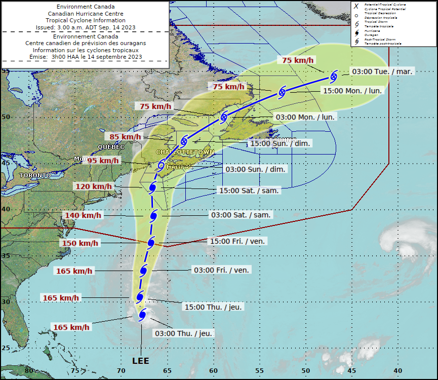
Hurricane Lee Takes Aim at Moncton: New Brunswickers Gear Up
As Hurricane Lee's eye draws nearer, New Brunswick residents diligently prepare for the imminent storm, especially in the Moncton region. The latest data reveals that the tempest is set to land in the Maritimes this coming Saturday.

Hurricane Lee’s Approach: What's Ahead for Moncton?
Renowned for its unpredictability, the hurricane season has been unforgiving this year. Hurricane Lee, the twelfth named storm of the Atlantic season, is currently veering northward. While Moncton sits in its projected path, experts anticipate Lee to metamorphose from a tropical to a post-tropical storm as it lands.
According to the Canadian Hurricane Centre, as of 3 p.m. Wednesday, Lee was pinpointed approximately 675 kilometres south-southwest of Bermuda. It propels north-northwest at approximately 25 km/h, flaunting fierce maximum sustained winds of 175 km/h.
"Despite its intimidating current stature, the hurricane is likely to expand further as it closes in on the East Coast," informed the Centre during a recent update. However, residents can breathe a sigh of relief as the storm's ferocity, gauged by its peak winds, will witness a decline. By the time it sweeps past Yarmouth, located at Nova Scotia’s southwestern pinnacle, Lee's status will drop just below a hurricane's by Saturday afternoon.
The Centre elaborated on the storm’s trajectory, hinting at its most intense impacts being felt predominantly on Saturday. However, weaker remnants of Lee might still linger on Sunday, potentially affecting parts of the region.
Despite projections, predicting the exact path of hurricanes remains a complex task. The latest forecast from the Centre suggests that the storm’s centre might touch down anywhere from Downeast Maine to western Nova Scotia. Regardless of its exact path, the storm's classification upon landfall is anticipated to range between a robust tropical storm or a post-tropical low.
Cautionary Measures and Pre-Storm Anticipations
The looming threat of Hurricane Lee has prompted the issuance of a tropical cyclone information statement encompassing all three Maritime provinces and specific areas of Quebec. This advisory underscores the imminent heavy rain and wind, urging residents to take requisite precautions.
"Our comprehensive analysis indicates that western Nova Scotia and southern New Brunswick are the prime targets for the fiercest winds. Simultaneously, regions extending from western New Brunswick to parts of the Bas-St-Laurent and Gaspesie in Quebec might witness the most substantial rainfall,” revealed the Centre.
The massive stature of Lee signifies widespread impacts. Coastal areas, particularly the Atlantic coast of mainland Nova Scotia and the Fundy coast of New Brunswick are poised for heightened water levels and towering waves.
The Canadian Hurricane Centre also voiced concerns regarding pre-storm rainfall. Bands of downpours traversing from southwest to northeast could inundate regions before Lee’s arrival. They stated, "These rainfall bands, notorious for their unpredictability, pose a significant flooding threat. The ramifications of Lee could accentuate the flooding risk.”
Considering the expansive size of Lee and its extended northward trajectory, Nova Scotia's Atlantic Coast braces for escalating surf conditions and menacing rip currents, especially as Friday approaches.
As we approach the end of the hurricane season, which traditionally spans from June 1 to November 30, it's essential to note the predictions from the National Ocean and Atmospheric Administration. They had previously forecasted 14 to 21 named storms for this season. Being the twelfth, Lee is a somber reminder of the volatile nature of our climate and the need for preparedness.
Conclusion
With Hurricane Lee on the horizon, the upcoming days will test the resilience and preparedness of the residents of Moncton and surrounding regions. As the storm edges closer, it's crucial to stay informed, adhere to local advisories, and ensure the safety of one's family and property. Together, the communities will weather the storm and emerge stronger on the other side.


